
Shop to Bay Bridge
| From: 1312 Main Chapel Way, Gambrills, MD 21054 To: 1312 Main Chapel Way, Gambrills, MD 21054 |
| Riding Distance: 46.8 miles |
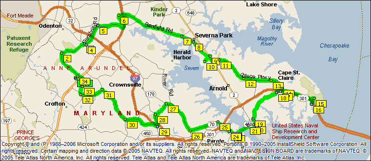 |
| Distance | Instruction |
| 0.0 | 1 Depart 1312 Main Chapel Way, Gambrills, MD 21054 on Main Chapel Way (East) for 76 yds |
| 0.1 | Turn LEFT (North-East) onto New Market Ln for 0.2 mi |
| 0.3 | Turn LEFT (North-West) onto Waugh Chapel Rd for 1.9 mi |
| 2.1 | 2 At 889 Waugh Chapel Rd, Gambrills, MD 21054, turn RIGHT (East) onto Dairy Farm Rd for 1.6 mi |
| 3.7 | 3 At Annapolis Rd, Gambrills, MD 21054, turn RIGHT (South-East) onto SR-175 [Annapolis Rd] for 0.1 mi |
| 3.9 | 4 At SR-175, Gambrills, MD 21054, turn LEFT (North-East) onto Gambrills Rd for 1.4 mi |
| 5.3 | 5 At 1301 Dicus Mill Rd, Severn, MD 21144, turn RIGHT (East) onto Dicus Mill Rd for 1.7 mi |
| 7.0 | Road name changes to Najoles Rd for 0.9 mi |
| 7.8 | 6 At 1099 Benfield Blvd, Millersville, MD 21108, turn RIGHT (East) onto Benfield Blvd for 1.4 mi |
| 9.3 | Road name changes to Benfield Rd for 2.8 mi |
| 12.1 | 7 At Evergreen Rd, Severna Park, MD 21146, turn RIGHT (South) onto Evergreen Rd for 0.8 mi |
| 12.9 | 8 At 100 Old County Rd, Severna Park, MD 21146, turn RIGHT (South) onto SR-648 [Baltimore Annapolis Blvd] for 1.3 mi |
| 14.2 | Turn LEFT (North-East) onto Jones Station Rd W for 153 yds |
| 14.3 | Road name changes to Local road(s) for 21 yds |
| 14.3 | Road name changes to Jones Station Rd for 109 yds |
| 14.4 | 9 At 3 Jones Station Rd, Arnold, MD 21012, return West on Jones Station Rd for 109 yds |
| 14.5 | Road name changes to Local road(s) for 21 yds |
| 14.5 | Road name changes to Jones Station Rd W for 0.4 mi |
| 14.9 | 10 At 1 Jones Station Rd W, Severna Park, MD 21146, return North-East on Jones Station Rd W for 0.4 mi |
| 15.3 | Turn RIGHT (South-East) onto SR-2 [Governor Ritchie Hwy] for 0.5 mi |
| 15.8 | Turn LEFT (East) onto College Pkwy for 0.4 mi |
| 16.2 | Bear LEFT (North) onto Local road(s) for 21 yds |
| 16.2 | 11 At Peninsula Farm Rd, Arnold, MD 21012, return South on Local road(s) for 21 yds |
| 16.2 | Turn LEFT (East) onto (E) College Pkwy for 2.0 mi |
| 18.2 | 12 At 300 Shore Acres Rd, Arnold, MD 21012, stay on College Pkwy (East) for 1.7 mi |
| 19.9 | 13 At 1299 Green Holly Dr, Annapolis, MD 21401, stay on College Pkwy (East) for 0.9 mi |
| 20.8 | 14 At 704 E College Pkwy, Annapolis, MD 21401, stay on E College Pkwy (South) for 2.1 mi |
| 22.9 | Road name changes to S Beach Rd for 0.2 mi |
| 23.0 | 15 At Oceanic Dr, Annapolis, MD 21401, turn RIGHT (South-West) onto Oceanic Dr for 0.4 mi |
| 23.5 | 16 At Oceanic Dr, Annapolis, MD 21401, return North on Oceanic Dr for 0.4 mi |
| 23.9 | Turn LEFT (West) onto S Beach Rd for 0.2 mi |
| 24.0 | Road name changes to E College Pkwy for 1.9 mi |
| 26.0 | Turn LEFT (South-West) onto Local road(s) for 153 yds |
| 26.1 | 17 At 1445 Whitehall Rd, Annapolis, MD 21401, return North-East on Local road(s) for 153 yds |
| 26.1 | Bear LEFT (North) onto (E) College Pkwy for 0.3 mi |
| 26.4 | Turn LEFT (South-West) onto SR-179 [St Margarets Rd] for 0.4 mi |
| 26.8 | 18 At St Margarets Rd, Annapolis, MD 21401, stay on SR-179 [St Margarets Rd] (South-West) for 2.4 mi |
| 29.2 | 19 At SR-179, Annapolis, MD 21401, turn LEFT (South-East) onto SR-648 [Baltimore Annapolis Blvd] for 0.2 mi |
| 29.5 | Turn RIGHT (West) onto Carvel Dr for 153 yds |
| 29.6 | Turn LEFT (South) onto Pendennis Dr for 0.2 mi |
| 29.7 | 20 At Pendennis Mount, return West on Pendennis Dr for 0.2 mi |
| 29.9 | Turn RIGHT (East) onto Carvel Dr for 153 yds |
| 30.0 | Turn RIGHT (South) onto SR-648 [Baltimore Annapolis Blvd] for 0.1 mi |
| 30.2 | Keep RIGHT onto Local road(s) for 98 yds |
| 30.2 | Bear RIGHT (West) onto SR-648 [Baltimore Annapolis Blvd] for 0.4 mi |
| 30.6 | 21 At Ritchie Hwy, Annapolis, MD 21401, turn LEFT (South-West) onto SR-450 [Baltimore Annapolis Blvd] for 1.0 mi |
| 31.6 | Keep STRAIGHT onto SR-435 [Annapolis St] for 0.2 mi |
| 31.8 | Keep STRAIGHT onto Annapolis St for 32 yds |
| 31.8 | 22 At Annapolis Chamber of Commerce, stay on Annapolis St (North-West) for 0.2 mi |
| 32.0 | 23 At 294 Annapolis St, Annapolis, MD 21401, turn LEFT (South-West) onto Monterey Ave for 131 yds |
| 32.1 | 24 At 297 Ridgely Ave, Annapolis, MD 21401, turn RIGHT (North-West) onto SR-436 [Ridgely Ave] for 0.9 mi |
| 33.0 | 25 At 646 SR-436, Annapolis, MD 21401, turn LEFT (South-West) onto N Bestgate Rd for 0.3 mi |
| 33.3 | Turn RIGHT (West) onto SR-70 [Bestgate Rd] for 0.2 mi |
| 33.5 | Road name changes to Bestgate Rd for 1.3 mi |
| 34.9 | 26 At 2061 SR-178, Annapolis, MD 21401, turn RIGHT (North-West) onto SR-178 [Generals Hwy] for 2.3 mi |
| 37.2 | 27 At 1102 Honeysuckle Ln, Annapolis, MD 21401, turn LEFT (South) onto Honeysuckle Ln for 1.0 mi |
| 38.2 | 28 At 1296 Honeysuckle Ln, Annapolis, MD 21401, turn LEFT (South) onto Crownsville Rd for 0.8 mi |
| 39.0 | 29 At 1843 Crownsville Rd, Annapolis, MD 21401, turn RIGHT (West) onto Chesterfield Rd for 2.2 mi |
| 41.2 | 30 At 1498 Chesterfield Rd, Crownsville, MD 21032, bear RIGHT (North-West) onto St Stephens Church Rd for 2.5 mi |
| 43.7 | 31 At St Stephens Church Rd, Crownsville, MD 21032, turn LEFT (South) onto Johns Hopkins Rd for 1.5 mi |
| 45.2 | 32 At Riedel Rd, Crofton, MD 21114, turn RIGHT (North) onto Riedel Rd for 0.5 mi |
| 45.7 | 33 At Riedel Rd, Crofton, MD 21114, stay on Riedel Rd (North) for 0.7 mi |
| 46.4 | Keep STRAIGHT onto Riedel Rd [Waugh Chapel Rd] for 54 yds |
| 46.4 | Road name changes to Waugh Chapel Rd for 0.2 mi |
| 46.6 | Turn LEFT (South-West) onto New Market Ln for 109 yds |
| 46.6 | 34 At 2699 Brandermill Blvd, Gambrills, MD 21054, stay on New Market Ln (South-West) for 0.2 mi |
| 46.8 | Turn RIGHT (North-West) onto Main Chapel Way for 76 yds |
| 46.8 | 35 Arrive 1312 Main Chapel Way, Gambrills, MD 21054 |
Crofton Bike Doctor and E3 Inc. presents these rides solely as a service to its customers and the cycling community, and makes no claims as to the fitness of these rides for any purpose. These route sheets are provided as guides only. Not responsible for any errors or road construction. Please note that since traffic and road conditions change, we can't guarantee the riding suitability of these routes. You are encouraged to use these maps as a guide to find places to explore the area, but you do so at your own risk. Please obey all the rules of the road and laws pertaining to cycling.
Copyright © and (P) 1988–2006 Microsoft Corporation and/or its suppliers. All rights reserved. http://www.microsoft.com/mappoint/ © Portions © 1990–2005 InstallShield Software Corporation. All rights reserved. Certain mapping and direction data © 2005 NAVTEQ. All rights reserved. The Data for areas of Canada includes information taken with permission from Canadian authorities, including: © Her Majesty the Queen in Right of Canada, © Queen's Printer for Ontario. NAVTEQ and NAVTEQ ON BOARD are trademarks of NAVTEQ. © 2005 Tele Atlas North America, Inc. All rights reserved. Tele Atlas and Tele Atlas North America are trademarks of Tele Atlas, Inc.