
LOCAL RIDES IN MARYLAND
OTHER STATES TOO IF YOU SCROLL LONG ENOUGH
Come in to the store and learn some of the great places Maryland and the surrounding area has to offer. One of our staff members will be more than happy to give you their suggestions and offer you some resources in our store. To get started check out the listings below. Check back often as we continue to add to the list!
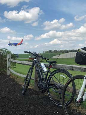 BWI Trail - Dixon Observation Area
Don't forget to check out our Cue Sheets for local area road rides located on the Home Page Menu.
PAVED TRAILS - ANNE ARUNDEL COUNTY
Baltimore & Annapolis Trail: This great local trail is 10 feet wide, paved and follows an old railroad route for more than 13 miles, straddling wildflowers and horse farms. Perfect for wheelchairs and rollerblades as well as bikes, it also joins the 12.5-mile Baltimore Washington International Trail, which encircles Baltimore Washington International (BWI) Airport via the John Overstreet Connector Trail.
Be sure to check out the Planet Walk between Glen Burnie and Severna Park. It is a 4.7 mile segment that has planet stations spaced proportionally from their distance from the sun. Historical markers along the trail, share the history which can be found in a guide book available at the Earleigh Heights Ranger Station at mile 7. (51 W Earleigh Heights Road, Severna Park, MD 21146) Downtown Annapolis is also easily accessible from the end of the trail. It includes a great ride over the Severn River Bridge, before enjoying the historical streets leading into downtown. The road is a little busy on the Annapolis side for a short distance. Then you will be on the streets of Annapolis. Take the lane and enjoy the scenery that the Naval Academy, St. Johns College and the historic homes offer as you pedal your way downtown. The B&A Trail is part of the East Coast Greenway, American Discovery Trail and the National Memorial Trail. Food and snacks are plentiful along the trail, with access to convenience stores and more. The Big Bean in Severna Park is a cyclist favorite with trailside seating with shade available. Parking options are abundant, a few are: the ranger station, Park and Ride lot in Arnold at RT2 and Jones Station, the Marley Station Mall. There is a trail lot at RT 50 and RT 450 and at the Dixon Observation Area.
Map
B&A Trail Information
The BWI Trail A 12.5 mile paved trail that encircles the BWI Airport. It connects to the B&A Trail via the John Overstreet Connector Trail. This is a very popular trail with local cyclists. It can be easily accessed from Friendship Park. Or ask us about the best way to link the trail with the local back roads and make it part of your road riding.
Be sure to check out the Thomas A. Dixon, Jr. Aircraft Observation Area (1911 Dorsey Road Glen Burnie, MD 21061) a great place to watch planes land. In the park is a playground for the children to enjoy, picnic benches and during the summer there is often a snow cone vendor. The bridge Crossing Stoney Run is a very scenic section of the trail. The route is mostly flat but there is a climb on the North East side of the ride before you experience great views of the airport and its operations at the Andover Observation Area. As you ride through the Andover Equestrian Center, you'll be on a short climb made easier with views of horses and modern art. There is a spur that will take you to the Linthicum Light Rail the BWI Amtrak MARC Station is also easily accessible from the trail.
Map
BWI Trail Information
W B & A Trail: Currently 7.1 miles in length and runs from RT 175 to the Two Rivers Community. This trail is easily accessed from the store via Waugh Chapel Road. It is about 2.8 miles from the front door of the shop with a wide shoulder to ride on to the trail.
The trail is on the old Washington Baltimore and Annapolis Electric Railway right away and soon be connected (late 2023 early 2024) to the Prince George side of the WB&A Trail via a bridge across the Patuxent River. This connector will add an additional 7.4 miles of trail with future plans connecting it to the Anacostia Tributary Trail System and downtown DC.
Trail highlights include the Piney Orchard Nature Preserve, the Little Patuxent River and fitness stations along the trail.
Parking is available at the Odenton Park (GORC) 940 Strawberry Lake Way Odenton, MD 21113 and at a trail parking lot on Patuxent Road (1181-1131 Patuxent Road, Gambrills, MD 21054) Limited roadside parking is available where the trail crosses Waugh Chapel Road.
The trail is part of the East Coat Greenway and the American Discovery Trail.
Map
WB&A TRAIL INFORMATION
WB&A Trail PG County
South Shore Trail: The trail will link the B&A Trail to the WB&A Trail and connect to the Annapolis Colonial Maritime Trail when fully complete it will be about 14 miles long. Currently it is about 1.97 miles long. The South Shore Trail primarily utilizes the abandoned road bed of the WB&A Railroad between Annapolis and Odenton. The trail will connect with the Colonial Annapolis Maritime Trail on the east end and the WB & A Trail on the west. The trail will be a component of the East Coast Greenway and the American Discovery Trail.
The closest access to the store is just off Millersville Road near Route 3 to Waterbury Road in Millersville. There is parking available at both termini, a few benches throughout, and beautiful scenery all around. While the trail is not complete it is very scenic be sure to check it out.
South Shore Trail Information
OTHER AREA PAVED TRAILS/RIDES
Cross Island Trail: Runs 6.5 miles from the Terrapin Nature Area to the Chesapeake Heritage & Visitors Center formally the Chesapeake Exploration Center at Kent Narrows. Walk, bike or skate amid warm and wonderful scenes of the Chesapeake Bay and local tributaries. It then joins the 1.2 mile Cross County Connector Trail.
Plan some time to explore the Chesapeake Heritage & Visitor Center, there are lots of fun things for the kids to enjoy. The continue on to Ferry Point Park to enjoy views of the Chester River, Kent Narrows and Piney Creek. If you are hungry you can recharge with one of the many restaurant and bar options in Kent Narrows.
Parking: Terrapin Nature Park, Old Love Point Park, Chesapeake Heritage and Visitor Center. Public lots under the Kent Narrows US 50/301 Bridge.
Restrooms and parking are also available at the Cross Island Trailhead at Macuum Creek. (1701 Piney Creek Road Chester, MD)
The Cross Island Trail is part of the American Discovery Trail.
Click here for more information. Or here for the Maryland DNR information.
Anacostia Tributary Trail System: A link in the national shore-to-shore American Discovery Trail, provides miles of uninterrupted trails along the tributaries of the Anacostia River. The southernmost point of the trail is located at Bladensburg Waterfront Park and spurs extend northeast and northwest along beautiful stream valley parkland. The trail system's continuous greenway traverses a variety of natural environments including woodlands, open fields, and wetlands. Click here for more information and a link to a map.
Western Maryland Rail Trail: This paved trail begins just west of historic Fort Frederick State Park and follows an easy grade along 25 miles of the Potomac River. You can also make a circuit with the C & O Canal trail. Click here for more information.
 Western Maryland Rail Trail
Oxford and St. Michaels - Located on Maryland's Eastern Shore, this is possibly one of the best places to ride in the state. This is a perfect weekend getaway area with great cycling and plenty to keep you entertained for the weekend. St. Michaels has some wonderful B&B's and restaurants to feed your hunger after a great day of riding. Be sure to check out the Oxford Bellevue Ferry while you are there. If you don't want to spend your entire time riding there are plenty of other activities close by such as golf and sailing. Below is a Cue Sheet from a local B&B on one of the basic ride routes. This area has also been home to the Bike Doctor Century.
Ride Description: Beginning in Easton, Cycling to Oxford & St. Michaels, Returning to Easton - 35.4 Miles
BEST SUITED FOR: Road Bicycles, Fitness Bicycles
FEATURES: Flat roads - wide shoulders in many areas lower traffic
Blackwater National Wildlife Refuge: Get a bike ride in while viewing the salt marsh ecosystem. Ride follows a road. Click here for more information.
Viewtrail 100: A well-marked, 100-mile route that begins and ends in historic Berlin. Flat lightly traveled back roads extend around farmland and the Pocomoke River State Forest. For more information visit the Worcester County web-site.
Charles County: A popular 23.4-mile excursion (45 miles round-trip) follows the escape route of John Wilkes Booth after he assassinated President Abraham Lincoln. Charles County boasts some of Maryland’s most scenic bike routes with light traffic, wide shoulders and many historic sites along the way. Route Information and map.
Charles County also offers a 30 Mile ride called the Amish Route, a 55 mile naturally Historic Route and the Heavenly Waters Route at 58 miles.
Charles County Rides: General Information - Updated 12/6/222
Somerset County Maryland Bicycle Rides
Old Town - Mt. Vernon Area
8 miles
Start: Mt. Vernon Road
End: Manokin River Park, Princess Anne - MAP
Blossoms Blooming
7 miles
Start: Princess Anne (Tourism Office 11440 Ocean Highway, Princess Anne MD 21853)
End: Worcester County Line/Beach to Bay Indian Trail MAP
Bridges Trail
10.5 miles
Start: Great Hope Golf Course, Westover
End Princess Anne (Tourism Office 11440 Ocean Highway, Princess Anne MD 21853) MAP
413 Rail to Trail
12 miles
Start: City Dock, Crisfield
End: Somerset County Recreation and Parks MAP
Crustacean Causeway
13.5 miles
Start: Crisfield Municipal Park
End: Somerset County Recreation and Parks MAP
Terrapin Run Recreation Trail
4.7 miles from Crisfield to Marian
CRUSHED STONES - PACKED DIRT - UNPAVED
Allegheny Highlands Trail: Connects with the 180-mile C&O Canal Towpath. This trail follows the route of the former Western Maryland Railroad for 22 miles from Cumberland to the Pennsylvania line. It then links other trail segments all the way to Pittsburgh. For more information click here.
C & O Canal Trail: Runs 184 miles from Cumberland to Georgetown on the old canal towpath. A peaceful, 10-mile “River Ride” starts at White’s Ferry near Poolesville and lets you pedal besides the Potomac River. Alternatively, some area cyclists take a few days and ride the whole trail. There's a lot of history and some great scenery along the way.
Click here for more information.
BEST SUITED FOR: Dual Sport, Cross Bicycles, Mountain Bikes, Fitness Bikes with moderate tires
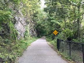
Torrey C. Brown Trail - Formally Northern Central Railroad (NCR): 41 miles of generally level pedaling on crushed, packed stone. The trail is an abandoned railroad bed amid rural countryside. On special occasions the trail is kept open for guided moonlight bike rides. Click here for more information.
Lower Susquehanna Heritage Greenways Trail: Follows a scenic ridgeline above the Susquehanna River from the Conowingo Dam to Deer Creek is a flat trail suited to family biking. Learn More
OFF-ROAD TRAILS
Bacon Ridge Natural Area: The first publicly accessible natural surface trail has been built by the county (Anne Arundel) in the summer/fall of 2015, and all three phases have been completed. The trail is located off of Hawkins Road, a few hundred yards past the overpass of 97. Approximately 18 miles of riding and hiking enjoyment.
Family Friendly: Yes - This trail is not super technical, it has twists, turns and has single track.
Annapolis Waterworks Trail: Consists of two loops with a connector trail. A natural surface multi use trail of approximately 7 miles in length. The southern Bacon Ridge trail head is about 1.5 miles for Annapolis Waterworks Trail so you can create a great riding adventure. The best access is off Housley Road in Annapolis near the Stone Point Apartments. You can also park at the Generals Highway Corridor Park, when leaving make a left on Crownsville Road, a right on Honeysuckle and the trailhead will be on your right. (There is no public parking at the trailhead. Please park at the park.)
Family Friendly: Yes
Patapsco Valley State Park: Nationally known for its advanced off-road riding trails, Patapsco is nicknamed “Moab of the East.” There is also a paved circuit trail to Swinging Bridge, a 300-foot suspension walkway crossing the Patapsco River. The park is a short drive from the store; take 195 away from the airport to Route 1 South, the park entrance is on the right. Feel free to ask us about our favorite trails and the current riding conditions—these trails are some of our favorites. Maryland DNR information on the park is here.
Rosaryville State Park: Rosaryville is a 982 acre day-use park and the location of the historic Mount Airy Mansion. Miles of trails for hiking, biking and equestrians are available for day use. This is a great place to take the mountain or cyclocross bike. The trail at the park is well suited for all levels of riders; it's some of the smoothest, best designed singletrack in the area. The main loop is approximately 10 miles in length. There's also an optional inner loop that's tight and technical, for those looking for a different challenge. To gain access to Rosaryville State Park, make a right turn into the entrance just south of Osborne Road while traveling south on U.S. 301. Maryland DNR information is here.
Family Friendly: Yes - This trail is not super technical, is very open in many places. The inner loop that has some obstacles but is not super technical and easily to go around.
Harrington Manor State Park and Garrett State Forest: Offers some moderately difficult single-track and dirt-road riding. Follow your bike ride with a swim in the lake. For more information visit the DNR site.
Seneca Creek State Park: The popular Schaeffer Farm Trail area has more than 12 miles of marked, off-road trails. Maryland DNR page. Park Trail Guide is located here.
Gambrill State Park: This park near Frederick is popular with hikers and area mountain bikers. The trails are rocky and cover a lot of elevation change, making riding here both technically challenging and aerobically strenuous. See what makes advanced East Coast mountain biking notorious—and bring suspension and plenty of water. We suggest a ride on the 4.6-mile Yellow trail. Here is the DNR website for more information.
Greenbrier State Park: Greenbrier is located on the next mountain ridge to the west of Gambrill, between Frederick and Hagerstown. There are mountain bike races held here, and riding these rocky trails can be a lot of fun. The trails are well marked, and several maps are posted along the way. There's also a lake by the parking area that's open for swimming in the summertime. Click here for more park information.
Fair Hill Natural Resource Management Area: Offers a huge network of off-road biking trails. Paths extend from each parking lot to join a 90-mile trail system featuring double-track for novice to moderate skills and single track for more advanced riding. Click here for more information.
Susquehanna State Park: Generally fast and dry, these off-road, single track trails require intermediate skills as you navigate small creeks, hills and varied terrain.
Green Ridge State Forest: Features nearly 100 miles of dirt roads and a challenging 11.6-mile wilderness loop with stream crossings, sustained climbs and steep turns. Several “easy-out” routes are available to shorten your ride. You may also enjoy a day hike on a new four-mile circuit trail. Or extend yourself on a 24-mile linear trail that stretches to 45 miles if you hook up with the C & O Canal Towpath. Park website. Mountain Biking Information for the Park.
Fountainhead Regional Park: Discover Fountainhead Regional Park, 2,000 acres of rugged adventures in Fairfax Station, Virginia. Whether you’re a cyclist, kayaker, hiker or miniature golf aficionado. Riders of all ability levels will enjoy the loops and features of our challenging mountain bike trail. Fountainhead Regional Park contains shared-use hiking and equestrian trails and provides trailhead access to the 19.7 mile Bull Run Occoquan Trail. Facebook Page Trail Information
REGIONAL PARKS
L.F. Cosca Regional Park (Prince George’s County): Various single-track options. Learn More
Cabin John and Black Hill (Montgomery County) Black Hill Regional Park is a 2.3 mile loop trail located near Boyds, MD and is rated as moderate. The trail is primarily used for hiking, walking, mountain biking, and canoeing and is accessible year-round. Learn More
Rockburn Branch Regional Park (Howard County): Can link up to trails at Patapsco Valley State Park. Learn More
For more information on these and other great areas to ride visit Maryland Park Information.
OTHER WEB RESOURCES
This is a great local resource for rides in and around the Maryland and DC area. Great cue sheets etc.
Crofton Bike Doctor and E3 Inc. have not used these cue sheets or done all of the rides. Ride at your own risk and please obey all rules of the road. Have a great ride and let us know what you thought.
MORE IDEAS
http://www.bikely.com/listpaths/country/254/region/142
http://mdbikeroutes.blogspot.com/
Top 20 Road Rides in Maryland - Komoot
Crofton Bike Doctor and E3 Inc. have not used these cue sheets or done all of the rides. Ride at your own risk and please obey all rules of the road. Have a great ride and let us know what you thought.
MOUNTAIN BIKE RIDES
Bikekinetix® is a mountain bike trails ride and resources guide to scenic, wilderness, historical or romantic cycling adventures in the Northeast U.S. and New England for experienced riders or beginners.
Maryland certainly offers an abundance of riding no matter what you are into. However many of us get the urge to explore other areas. Below are some links to get you started on rides in some of our neighboring states. If you have a favorite ride let us know and we will post it here.
PENNSYLVANIA RIDES
Great Allegheny Passage - GAP
From the GAP Website.
"The 150-mile Great Allegheny Passage soars over valleys, snakes around mountains, and skirts alongside three rivers (the Casselman, Youghiogheny, and Monongaleha) on its nearly level path. Cyclists pass through the Cumberland Narrows, cross the Mason-Dixon Line, top the Eastern Continental Divide at 2,392’, weave through the breathtaking Laurel Highlands, wind their way through 19,052-acre Ohiopyle State Park, journey through the region’s coke, coal, mining, and steel-making corridor, and end at Pittsburgh’s majestic Point State Park."
Pair this with a ride on the C & O Canal an you can ride all the way from Washington DC to Pittsburgh by bike. This is a very popular trip for many of our customers. You can even place your bike on a train for transportation.
Montour Trail
From the Montour Trail Website:
"The Montour Trail is a multi-use, non-motorized recreational pathway around Pittsburgh, the country’s longest suburban rail-trail. The main line extends 47.4 miles; branch routes increase the overall length to 63 miles. The relatively-flat half-loop stretches from Coraopolis (13 miles northwest of Pittsburgh along the Ohio River) to Clairton (15 miles southeast of the city, on the Monongahela River). A branch in the northwest section connects directly to the Pittsburgh International Airport."
Pine Creek Rail Trail
62 Miles of Scenic Riding for the entire family. Located in Pennsylvania's "Grand Canyon"
Mountain Biking at Raystown
Spend a weekend or a week mountain biking and camping at Raystown.
Pennsylvania offers a lot of great places to ride check them out at:
http://www.dcnr.state.pa.us/stateparks/recreation/biking.aspx
Here is detailed information on riding in Pennsylvania Dutch Country:
http://www.dcnr.state.pa.us/stateparks/recreation/biking_dutch.aspx
Philadelphia and Its Countryside:
http://www.dcnr.state.pa.us/stateparks/recreation/biking_philadelphia.aspx
Northeast Pennsylvania Mountain Region:
http://www.dcnr.state.pa.us/stateparks/recreation/biking_northeast.aspx
Central Mountains and Valleys:
http://www.dcnr.state.pa.us/stateparks/recreation/biking_central.aspx
RIDES IN VIRGINIA
The state of Virginia has a great resource for rides. Check it out at : http://www.vabike.org/links.htm
RIDES IN WEST VIRGINIA
Check out http://www.bicyclewv.com/ for great information on all of the riding available in West Virginia. Many consider West Virginia a mountain biking mecca check it out for yourself.